
Waipahu Neighbor Records by Block
Official sources describe different parts of a Waipahu block. HOLIS supplies parcel shapes and regulatory geography. RPAD ties a Tax Map Key, or TMK, to an assessed owner, situs, mailing address, building facts, and sales fields. BOC adds recorded interests and transfer dates. Permit files describe approved work. Election records offer only the narrow public fields allowed by Hawaiʻi law, and Neighborhood Board records document civic issues rather than private households.
| Source | What It Shows About a Block | Access |
|---|---|---|
| HNL Reg Parcel Selector | Tax parcel, regulatory parcel, address ID, address label, and nearby geometry | Free public map; controls partly documented |
| Honolulu RPAD | Owner, situs and mailing fields, assessment, structure, sales, and tax facts | Online qPublic plus office routes |
| Bureau of Conveyances | Parties, deed type, recording date, and title links for each parcel | Account search; paid images; older records offline |
| Honolulu Elections | Public name, district or precinct, and status fields | Official records routes |
| Neighborhood Board No. 22 | Agendas, minutes, testimony, meetings, and civic issues | Public city pages and requests |
The strongest inventory records only what each source proves. A map proves mapped adjacency on a dated layer. RPAD proves what appears in the assessment file. A deed proves a recorded transaction or interest, not present occupancy. Community records may show a speaker or participant, but they do not establish where that person lives.
Select Waipahu Neighbor Parcels
Open the HNL Reg Parcel Selector with the subject address or TMK. The interface identifies Current Tax Parcel, Current Regulatory Parcel, Current Address ID, and Current Address Label. Save the subject parcel first. Then record each touching or facing parcel, including its TMK, address label, and position relative to the subject.
The official parcel-selector entry captured for Waipahu shows the starting point for that work.
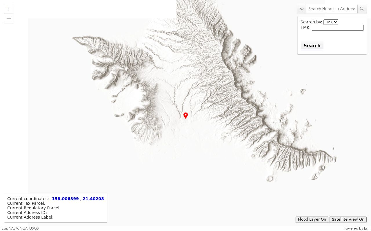
The researched interface did not confirm a buffer tool, full layer menu, export command, or automatic neighbor list. Save parcels manually rather than claiming the viewer builds a resident roster. State metadata says Oʻahu parcel layers are a visual reference, not survey proof.
Map Waipahu Neighbors Carefully
A consistent process keeps the block small and prevents unrelated street results from creeping in. Choose a rule before searching, such as parcels touching the subject, parcels facing it, or all parcels inside one clear block face. Apply that rule to every side.
- Find the subject address in HNL Reg Parcel Selector and save its TMK and dated map view.
- Inventory adjacent TMKs before searching names, so geography drives the work.
- Run each parcel through Honolulu RPAD and save owner, situs, mailing, and record date separately.
- Use BOC when a transfer date or title interest is needed, and label the instrument type.
- For a full named street, use the Waipahu street directory workflow.
Never infer occupancy from a home-exemption field or matching owner and situs addresses alone. Such details may strengthen a clue, but they do not identify every person at the property. Apartments, condominiums, flag lots, and shared drives also require care because visual closeness may not equal legal adjacency.
Waipahu Owners Are Not Occupants
RPAD can display both a situs address and an owner mailing address. The situs is the taxed property. The mailing field is where notices go, which may be a post office box, trust, company, accountant, relative, or another property. OIP Opinion 11-01 treats owner mailing-address data as public real-property-tax information, but that status does not make it proof of residence.
A clean neighbor worksheet needs separate columns for parcel owner, situs, mailing destination, source date, and occupancy evidence. Leave occupancy blank unless a distinct lawful source supports it. This small distinction prevents a property clue from becoming a false personal profile.
Note: Matching mailing and situs fields strengthen a clue but do not identify every person occupying a Waipahu parcel.
Waipahu Neighbor Civic Records
Neighborhood Board No. 22 is Waipahu’s official civic umbrella. Formed in 1984, it publishes meeting details, agendas, minutes, testimony routes, and board contacts. These records can reveal issues affecting the block, such as traffic, planning, public works, and services. They are not a roster of all Waipahu neighbors.
Neighborhood Board 22
Meeting and records page
Public meeting details, testimony route, and civic records.
Waipahu Public Library
Branch information
Catalog help, computers, newspaper access, copies, and archive referrals.
No comprehensive official directory of Waipahu homeowners associations was found. Do not invent one or treat a civic board as an HOA. For an association tied to a planned community, verify its legal name through recorded subdivision documents or the official business registry before relying on a private roster.
Waipahu Voter Data Is Narrow
Hawaiʻi law makes a current voter’s full name, district or precinct designation, and voter status public under HRS §11-97. Other affidavit information remains confidential except for election or government purposes. The Online Voter Registration and Lookup lets a voter verify or update their own record using identity details. It is not a public name-and-address directory for a block.
Precinct geography can test whether addresses share an election area, but it cannot establish a household. Waipahu CDP, ZIP 96797, Neighborhood Board 22, precinct, TMK, and regulatory parcel boundaries overlap without matching. Record which geography supplied each result, especially near an edge.
Official Waipahu Neighbor Lookup
Official records and commercial tools serve different purposes. A commercial result may merge old addresses, namesakes, phone data, and unknown sources. It can be quick, but it often hides the date and legal meaning of a fact. Official systems take more steps, yet each result points back to a custodian and record type.
| Method | Strength | Limit |
|---|---|---|
| HOLIS and RPAD | Dated parcel and assessment context | Owner does not equal occupant |
| BOC and DPP | Recorded interests and property work | Do not identify a full household |
| Commercial category | Broad name and address suggestions | Provenance, dates, and merged identities may be unclear |
Use a commercial hit, if encountered, only as a clue. Confirm every material point with the office keeping the source record, and discard any person or address that does not match the parcel and date under study.
Historical Waipahu Neighbors Shift
A modern block can be a poor frame for plantation-era neighbors. Sources may use camp, mill, railroad, ahupuaʻa, Waikele, Waipio, Ewa, or Oʻahu labels. Fire-insurance maps from the researched 1879–1955 series show structures, lots, streets, and industrial context. Later city directories use a street index from 1908, while phone-book runs supply subscriber clues with gaps.
To reconstruct a past block, match the period street or camp label to a map, then use its address index and alphabetical directory entry. Compare nearby names only within that dated source. A person printed beside another entry is not necessarily a relative, social neighbor, or present-day parcel occupant.
Compare Waipahu Parcel Timelines
Two adjacent parcels can have very different histories. When a present owner name is not enough, use the Bureau of Conveyances Data Search to compare recording dates and instrument types. Search is free after account registration, while document images are paid. Online image and index coverage begins in 1976. Earlier work shifts to the public reference room or a written request with a document number, Book/Page, or party names.
Start with each parcel’s TMK and latest RPAD sales or instrument clue. In BOC, distinguish a deed from a mortgage, release, lien, notice, or correction. Save grantor, grantee, recording date, document number, system, and parcel description. A named party is not always an owner, and a transfer says nothing by itself about who occupied the lot. Comparing dated transfer lines can explain why assessment names changed at different times without turning the block into a personal dossier.
Property work offers another timeline. Honolulu DPP’s HNL Build can find current permit status by application number, permit number, or TMK. Full files may require a Request to View Records or the Data Access Imaging Branch. Historic Hawaiʻi’s research guide notes that permits before January 1972 are not online. An absent web result is therefore an access clue, not evidence that no alteration took place.
This distinction matters on an older Waipahu block. A subdivided lot, rebuilt structure, address change, or shared access lane may explain what the current parcel map shows. Keep permit facts tied to the structure and TMK. Do not assign a contractor, applicant, former owner, or neighboring parcel to a household without another dated source.
Note: Compare parcels on the same source date because assessment, GIS, permit, and deed systems update on different schedules.
Waipahu Neighbor Privacy Limits
Public parcel and tax files do not reveal every resident, guest, child, family tie, or daily routine. Voter affidavit details are restricted beyond the narrow public fields. Vital certificates require a direct and tangible interest or another statutory basis. Utility, delivery, school, and private membership data do not become public because someone wants a block list.
Hawaiʻi’s Address Confidentiality Program provides a substitute address for eligible survivors of domestic abuse, sexual offenses, or stalking. Never try to reverse that protection. If an actual protected location appears, contact the custodian about confidentiality or redaction rather than copying it.
Lawful use. A Waipahu neighbor lookup may support civic curiosity, reconnection, or personal safety. Never use it to watch, threaten, intimidate, or harass anyone.